
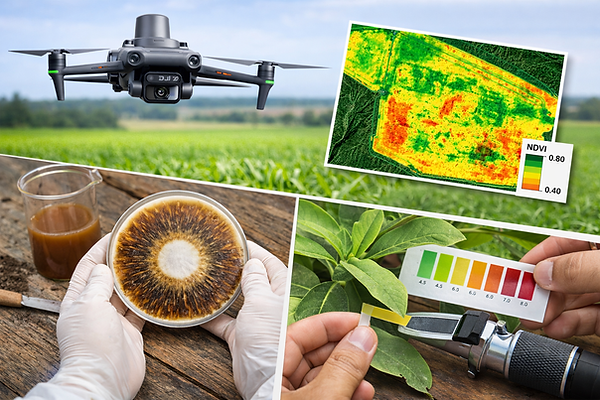
Mavic 3 Multispectral Mapping
Discover what human eye can't see.

PRECISION AGRICULTURE
Nutrient deficiencies, soil imbalances, pest pressure, disease development and other factors often begin affecting crop performance long before symptoms become visible to the human eye.
Using the DJI Mavic 3 Multispectral, we generate high-resolution vegetation maps that help identify variability across the field, allowing producers capture valuable information that supports better monitoring and more informed decision making.

Licensed Commercial Drone Operations (ReOC 9537)
CASA Certified Drone Pilots


Early Detection
Identify stress before visible symptoms appear.

Input Efficiency
Apply inputs only where needed and reduce waste.

Lower Costs
Reduce chemical use and unnecessary applications.

Increase Productivity
Healthier crops and better decisions lead to higher yields.
Environmental Impact
Support sustainable farming and lower your environmental footprint.
Beyond the Map
Many mapping services stop at delivering imagery.
When combined with tools such as Plant Health Assessment and Biological Soil Health Assessment, multispectral mapping becomes part of a broader very powerful diagnostic process that helps build a more complete picture of the farming system.
BETTER DATA, BETTER DECISIONS.
Drone Mapping vs Satellite Imagery
Field Investigation
Satellite images can help provide a broad overview.
Drone mapping goes further by capturing detailed, high-resolution information directly from your crop.
That difference matters. Because when you are making decisions that affect yield, input costs, and crop performance, working with real measurements instead of approximations gives you a much higher level of confidence and precision.

Spatial Resolution
Timing
Cloud Coverage
Data Accuracy
Variability Detection
Decision Quality


2-3 cm / pixel
On-demand flights
Cloud independent
5-30 m / pixel
Depends on satellite pass
Affected by clouds
Actual field conditions
Generalized estimation
Plant-by-plant detail
Broad area averages
High confidence decisions
Lower confidence decisions
Better data quality means better agronomic decisions.

Targeted inspection of specific areas.

Monitoring & Record Building
Track changes over time and support future decision making.


Stop guessing
Start meassuring it

